


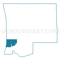
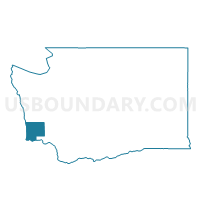
Pioneer Voting District, Pacific County, Washington
About
Outline

Summary
| Unique Area Identifier | 687838 |
| Name | Pioneer Voting District |
| County | Pacific County |
| State | Washington |
| Area (square miles) | 35.13 |
| Land Area (square miles) | 9.90 |
| Water Area (square miles) | 25.23 |
| % of Land Area | 28.18 |
| % of Water Area | 71.82 |
| Latitude of the Internal Point | 46.38230590 |
| Longtitude of the Internal Point | -124.05815730 |
Maps

Graphs
Select a template below for downloading or customizing gragh for Pioneer Voting District, Pacific County, Washington


Neighbors
Neighoring Voting District (by Name) Neighboring Voting District on the Map
- Klipsan Voting District, Pacific County, WA
- Long Beach City Voting District, Pacific County, WA
- Nahcotta Voting District, Pacific County, WA
- Naselle Voting District, Pacific County, WA
- Seaview 1 Voting District, Pacific County, WA
- Seaview 2 Voting District, Pacific County, WA
Top 10 Neighboring County Subdivision (by Population) Neighboring County Subdivision on the Map
- Long Beach-North Beach Peninsula CCD, Pacific County, WA (9,107)
- Naselle CCD, Pacific County, WA (2,320)
Top 10 Neighboring Place (by Population) Neighboring Place on the Map
Top 10 Neighboring Unified School District (by Population) Neighboring Unified School District on the Map
Top 10 Neighboring State Legislative District Lower Chamber (by Population) Neighboring State Legislative District Lower Chamber on the Map
Top 10 Neighboring State Legislative District Upper Chamber (by Population) Neighboring State Legislative District Upper Chamber on the Map
Top 10 Neighboring 111th Congressional District (by Population) Neighboring 111th Congressional District on the Map
Top 10 Neighboring Census Tract (by Population) Neighboring Census Tract on the Map
- Census Tract 9504, Pacific County, WA (3,921)
- Census Tract 9507, Pacific County, WA (2,995)
- Census Tract 9505, Pacific County, WA (2,475)
- Census Tract 9506, Pacific County, WA (1,263)
- Census Tract 9901, Pacific County, WA (0)